Caity Seifert, Project Coordinator
In autumn 2023, Alberta experienced the onset of a strong El Niño event. This climatic phenomenon led to above-average temperatures and a striking lack of snowfall throughout the province, exacerbating an already dry late summer. Such conditions have created a substantial moisture deficit across the province, particularly in Northern Alberta, setting the stage for potential water resource challenges in the coming year.
Empowering Communities: The “Building Resiliency to Multi-Year Drought in Alberta” Guidebook and Workshops
In Alberta’s history, we’ve seen the devastating impacts of droughts, some lasting close to a decade. It is hard to predict when an unusually dry season could turn into a multi-year drought, but the drought we are currently experiencing isn’t just a temporary challenge; it’s a reminder to reevaluate and strengthen our approaches to environmental and resource management.
The Alberta Water Council’s “Building Resiliency to Multi-Year Drought in Alberta” is a collaborative initiative by the Alberta Water Council and Alberta’s eleven Watershed Planning and Advisory Councils (WPACs). They developed a guidebook and workshop materials to assist WPACs as they engage municipalities and communities within their watershed to better plan for, mitigate, respond to, and recover from multi-year droughts. Collectively, this guidebook and the workshops offered by local WPACs aim to enhance the resilience of communities and aid municipalities in planning and implementing drought resiliency measures.
The workshops explore central themes, such as drought monitoring, supply and demand management, land-use planning, agriculture, ecological systems, community health, public education, collaboration, and emergency management. It promises to be an enlightening experience, offering attendees insights from community experiences, strategies for managing droughts, and opportunities to foster collaborative partnerships for water management. This workshop isn’t just about responding to the current drought; it’s about preparing for the future, learning from the past, and growing stronger communities.
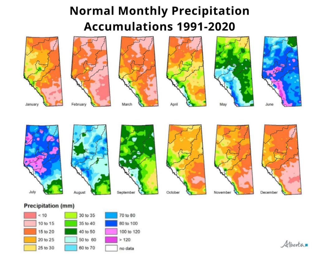
A Look at Precipitation Patterns and Multi-Year Droughts in Alberta’s Northern Watersheds
Climate patterns and multi-year droughts in Alberta’s northern watersheds play a crucial role in shaping the region’s ecosystem and managing water resources. These watersheds are particularly vulnerable to the impacts of climate change, as they are highly dependent on snowpack and glacier melt for their water supply. Changes in precipitation patterns, temperature increases, and variations in snow accumulation can lead to prolonged drought conditions, affecting water availability for ecosystems, industry, agriculture, and communities.
Alberta’s northern watersheds experience precipitation variability due to climate change, natural climate cycles like El Niño and La Niña, and local geographical features. Multi-year droughts, which are periods of significantly below-average precipitation over several years, can have severe consequences on the environment, agriculture, industries, and communities relying on these water sources.
As a large province, Alberta exhibits diverse climate patterns across different regions. Furthermore, the context of human use and the local landscape means the influence on specific water bodies can vary significantly. It is essential to monitor precipitation patterns, assess the risk of droughts, and develop sustainable water management strategies to mitigate the impacts of prolonged dry spells in these watersheds.
Understanding these climate patterns and anticipating the effects of multi-year drought is essential for effective water resource management and guiding adaptation strategies. This information is invaluable for policymakers, water managers, and stakeholders in developing sustainable water management practices and policies to mitigate the impacts of drought on Alberta’s northern watersheds.
Through continued research, monitoring, and collaboration, efforts can be made to improve resilience and preparedness for drought events in these watersheds. By raising awareness about the importance of putting climate patterns and the risks of multi-year droughts into a local context, we can work towards a more sustainable future for Alberta’s northern watersheds and the communities that rely on them.
Let’s explore the precipitation patterns and the current drought situation for the Athabasca Watershed.
Average Annual Precipitation Accumulation
- Upper Athabasca (near Edson): ~535 mm
- Central Athabasca (near Athabasca): ~455 mm
- Lower Athabasca (near Fort McMurray): ~440 mm
Average Precipitation Accumulation for November to March (Cold Season)
- Upper Athabasca (near Edson): ~100 mm
- Central Athabasca (near Athabasca): ~80 mm
- Lower Athabasca (near Fort McMurray: ~90 mm
Average Precipitation Accumulation for April to September (Growing Season)
- Upper Athabasca (near Edson): ~415 mm
- Central Athabasca (near Athabasca): ~340 mm
- Lower Athabasca (near Fort McMurray: ~315 mm
Around 20% of the total annual precipitation in the Athabasca watershed is contributed by cold season precipitation. This does not seem like a significant amount. Still, when 20% of annual precipitation is stored as snowpack, this snow accumulation plays a critical role in the hydrological cycle and significantly influences water resources.
During the winter months, sustained low temperatures lead to precipitation falling as snow, which accumulates as snowpack. This snowpack acts as a temporary storage for water. As temperatures rise in the spring and early summer, the snowpack melts, contributing to river flows. This seasonal meltwater is essential for replenishing reservoirs, groundwater, and soil moisture, which can be critical for the health of ecosystems, agriculture, and human water consumption.
This stored snowpack typically begins to release water in the spring thaw, which can be observed as a significant increase in runoff. This often leads to higher river levels and sometimes flooding, depending on the volume of snow and the rate of the melt. The snowmelt peak is a crucial period for water management in the watersheds.
Moreover, the snowpack’s gradual melting process can provide a sustained flow into rivers and streams well into the summer months, which is particularly important during periods when there is little rain. This sustained release can help maintain streamflow during the dry season, supporting aquatic habitats and providing water for agricultural use.
Climate variability and change can alter these patterns, influencing the timing and intensity of snowfall and melt periods, which can have significant implications for water resource management. Snowpack monitoring is an essential aspect of managing water resources in Alberta’s northern watersheds.
Gaining Insights into Athabasca Watershed’s Current Drought Conditions
Recent data captured over a 90-day period from November 24th, 2023, to February 21st, 2024, offers a vivid portrayal of the precipitation trends across various sub-basins in Alberta.
Through detailed maps obtained from the Alberta Climate Information Service, we gain insights into the quantity of rain or snowfall and the deviation from long-term norms.
Actual Precipitation Received

The first map in our analysis presents a colour-coded overview of the precipitation received during the past 90 days. The colour gradations indicate areas that have received less than 5 mm of rain or snow—to those that have received up to 80 mm, which may be faring better but still deviating from the norm.
Precipitation Accumulations Relative to Long-Term Normal

This second map shows how those numbers in the first map compare to the historical average or the ‘precipitation accumulations relative to the long-term average.’ The range of conditions spans from ‘driest’—indicating a rare event occurring less than once in 50 years—to ‘wettest,’ with similar rarity. This map is a powerful tool for understanding the frequency and severity of drought conditions in different sub-basins. For instance, large portions of the watershed showcase notably low precipitation levels compared to the long-term averages, hinting at potential drought conditions that may warrant further monitoring and drought planning.
Synthesizing the Data
Combining the insights from all maps, a narrative emerges of a region in the midst of a drought. The visual data prompts us to ask important questions:
- How do these conditions affect the water availability in the Athabasca Watershed?
- What are the implications for economic sectors?
- How can policymakers and stakeholders collaborate to mitigate the adverse effects of these drought conditions?
Moving Forward
As we confront the realities of climate variability, these maps remind us of the importance of robust, data-driven approaches to environmental management. They illustrate the current state of precipitation in Alberta and underscore the need for sustainable water management practices and drought preparedness strategies.
These visualizations are a call to action for residents, industry, farmers, and policymakers in Alberta. The maps tell a story of a variable climate and the pressing need for awareness and adaptation. They highlight the necessity for adaptive measures tailored to each region and community’s needs. Attending the Building Resiliency to Multi-Year Drought in Alberta will provide the opportunity to do just that.
In conclusion, the Athabasca watershed is experiencing varied precipitation levels, with some areas facing potential drought conditions. It is critical to continue monitoring these trends and to use the data available to inform a coordinated response to drought. By understanding and anticipating the complexities of drought, communities can forge a path toward greater environmental stability and resource security.
For additional maps and meteorological data, please visit weatherdata.ca.