Petra Rowell, Executive Director, Athabasca Watershed Council
After taking part in the Fort Assiniboine Bicentennial Voyageur Canoe Brigade this summer (read more about the brigade here), I was interested in reading about the days when our northern rivers were the ‘highways’ for trade and exploration. I picked up a book about David Thompson’s travels to learn more about one of Canada’s great geographers and his travels in the Athabasca watershed[1].
One of Thompson’s earliest achievements as a geographer was to explore and map a shorter route north to Lake Athabasca, via the Churchill River, rather than by the longer route using the Saskatchewan River system. In the spring of 1796, then as an employee of the Hudson’s Bay Company, Thompson and two Chipewyan guides paddled into northern Saskatchewan, ascending the Churchill and Reindeer Rivers to Reindeer Lake, across to Manito (later named Wollaston) Lake and up the Black River to the east end of Lake Athabasca.
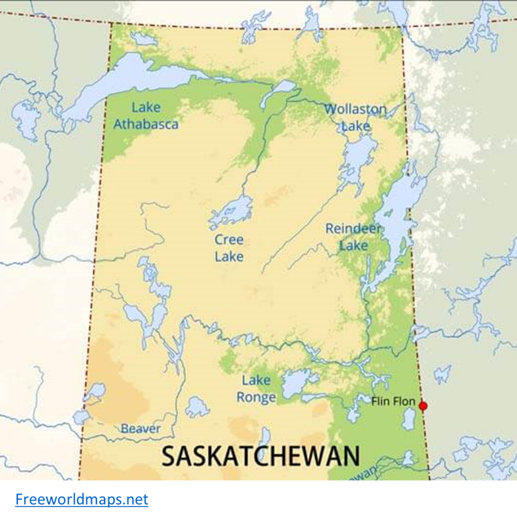
In his writings, Thompson noted that Wollaston Lake, the source of Lake Athabasca, is a bifurcation lake. That is, unlike many lakes that only have one outlet, Wollaston Lake has two outlets, which drain in opposite directions. One outlet drains about 10% of the lake to the west (eventually draining into Lake Athabasca and the Mackenzie watershed). The other 90% of the lake drains to the east via the Cochrane River, which flows into Reindeer Lake, which drains via the Churchill River into Hudson Bay, considered an arm of the Atlantic Ocean.
After many years of traveling throughout the northwest, Thompson and his companions, guided by an Iroquois man named Thomas, again made a significant achievement. They crossed the Rocky Mountains via the Athabasca Pass (south of today’s Town of Jasper), reaching the forks of the Columbia and Canoe rivers on January 18, 1811.
Interestingly, this event also included the notation of a bifurcation lake! At the height of the pass, there is a small glacial lake subsequently named by Governor George Simpson as the Committee’s Punch Bowl; a reference to the London Committee of the Hudson’s Bay Company. Today, as hikers pass the lake, they often stop and raise a toast to the Governor!

The Committee’s Punch Bowl drains to two oceans. Its northwest outlet is the source of the Whirlpool River, a tributary to the Athabasca River which drains into Lake Athabasca, which continues to flow through the Peace / Slave / Mackenzie system and into the Arctic Ocean. The southern outlet drains to Pacific Creek / Wood River and then the former Canoe River (now impounded and called the Canoe Reach of Kinbasket Lake), a reservoir of the Columbia River which runs to the Pacific Ocean in Oregon.
Working for the Athabasca Watershed Council, I am in constant awe of the size of the Athabasca watershed, which within Alberta, makes up about 24% of the province’s land base. Learning about how the Athabasca is connected to waterways that flow to the Pacific, Arctic and Atlantic is equally impressive. Elements like hot springs, water falls and bifurcation lakes add even more interest to the study and understanding of these endlessly fascinating waterways.
For more information, see:
David Thompson; Dictionary of Canadian Biography (Sept. 7 2023)
Wollaston Lake Wikipedia (Sept. 7 2023)
Athabasca Pass National Historic Site of Canada (Parks Canada) (Sept. 7 2023)
Committee’s Punch Bowl Wikipedia (Sept. 10 2023)
Solo Trip up to the Athabasca Pass MartyUpNorth YouTube (Sept. 7, 2023)